Main Content

    stdClass Object
(
    [type] => Land
    [status] => stdClass Object
        (
            [current] => Pending
            [last] => Active
            [changed] => stdClass Object
                (
                    [$date] => 2025-05-29T12:41:35Z
                )

        )

    [ml_number] => 7575669
    [price] => stdClass Object
        (
            [amount] => 9076100
            [original] => 9076100
            [last_changed_on] => stdClass Object
                (
                    [$date] => 2025-05-08T11:20:35Z
                )

        )

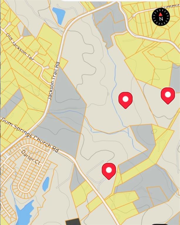
    [description] => The 160 acre assemblage near Traditions of Braselton Golf Course in Jackson County, Georgia, presents a prime opportunity for residential development. This property comprises three tracts and offers significant potential for developers and investors. These 3 properties have frontage on Jackson Trail rd, Gum Springs Ch Rd and Otis Gooch Rd.  Key Features:  Utilities: County water and natural gas are readily available. Sewer access is located across the road; however, a lift station will be required for connection.  Surrounding Development: A substantial subdivision is currently under construction directly across the road, indicating strong growth and demand in the area.  Proximity to Amenities: The property is very close to the Traditions of Braselton Golf Course, a master-planned community offering amenities such as a golf course, resort-style pool, tennis and pickleball courts, and a clubhouse .  Development Potential:  Given its size, location, and available utilities, this assemblage is well-suited for a large-scale residential development. The ongoing construction of nearby subdivisions further underscores the area's attractiveness for such projects.
    [location] => stdClass Object
        (
            [city] => Jefferson
            [state] => GA
            [postal_code] => 30549
            [county] => Jackson - GA
            [lot] => 3 lots
            [street] => stdClass Object
                (
                    [number] => 2321
                    [name] => Gum Springs Church Rd.
                    [full] => 2321 Gum Springs Church Rd.
                )

            [directions] => I-85 north exit 129, turn right to left on Hwy 124, go past Tradtions of Braselton Golf course to right on Gum springs Ch rd, go thru stop sign at Jackson Trail Rd and see property on left.
            [coordinates] => stdClass Object
                (
                    [latitude] => 34.069847
                    [longitude] => -83.670703
                    [geo_json] => stdClass Object
                        (
                            [type] => Point
                            [coordinates] => Array
                                (
                                    [0] => -83.670703
                                    [1] => 34.069847
                                )

                        )

                )

        )

    [building] => stdClass Object
        (
            [fireplaces] => stdClass Object
                (
                    [exists] => 
                )

        )

    [surroundings] => stdClass Object
        (
            [utilities] => Array
                (
                    [0] => Electricity Available
                    [1] => Natural Gas Available
                    [2] => Phone Available
                    [3] => Water Available
                )

            [land] => stdClass Object
                (
                    [size] => stdClass Object
                        (
                            [dimensions] => 1200x1200
                            [acres] => 165
                        )

                    [description] => Array
                        (
                            [0] => Level
                            [1] => Open Lot
                        )

                )

            [school] => stdClass Object
                (
                    [elementary] => Gum Springs
                    [junior] => West Jackson
                    [high] => Jackson County
                )

        )

    [last_updated] => stdClass Object
        (
            [$date] => 2025-05-29T16:29:32Z
        )

    [office] => stdClass Object
        (
            [name] => Re/Max Towne Square
            [broker_id] => RMTS01
            [broker_phone] => 770-771-6767
        )

    [agents] => Array
        (
            [0] => stdClass Object
                (
                    [name] => stdClass Object
                        (
                            [first] => KEN
                            [last] => BYCE
                        )

                    [phone] => stdClass Object
                        (
                            [preferred] => 706-658-6058
                            [mobile] => 706-658-6058
                            [fax] => 706-367-7760
                        )

                    [agent_id] => BYCE
                )

        )

    [media] => stdClass Object
        (
            [virtual_tours] => Array
                (
                    [0] => https://www.propertypanorama.com/2321-Gum-Springs-Church-Rd-Jefferson-GA-30549/unbranded
                )

            [photos] => Array
                (
                    [0] => stdClass Object
                        (
                            [position] => 1
                            [description] => Map / location with property boundaries highlighted
                            [urls] => stdClass Object
                                (
                                    [original] => https://new.photos.idx.io/fmls-reso/7575669/7cf5522dedc2acae3eba72b3352f0d7d-m1.jpg
                                    [215x] => https://new.photos.idx.io/fmls-reso/7575669/7cf5522dedc2acae3eba72b3352f0d7d-m1/215x.jpg
                                    [440x] => https://new.photos.idx.io/fmls-reso/7575669/7cf5522dedc2acae3eba72b3352f0d7d-m1/440x.jpg
                                )

                        )

                    [1] => stdClass Object
                        (
                            [position] => 2
                            [description] => Map of property location featuring property boundaries highlighted
                            [urls] => stdClass Object
                                (
                                    [original] => https://new.photos.idx.io/fmls-reso/7575669/7cf5522dedc2acae3eba72b3352f0d7d-m2.jpg
                                    [215x] => https://new.photos.idx.io/fmls-reso/7575669/7cf5522dedc2acae3eba72b3352f0d7d-m2/215x.jpg
                                    [440x] => https://new.photos.idx.io/fmls-reso/7575669/7cf5522dedc2acae3eba72b3352f0d7d-m2/440x.jpg
                                )

                        )

                    [2] => stdClass Object
                        (
                            [position] => 3
                            [description] => Aerial overview of property's location
                            [urls] => stdClass Object
                                (
                                    [original] => https://new.photos.idx.io/fmls-reso/7575669/7cf5522dedc2acae3eba72b3352f0d7d-m3.jpg
                                    [215x] => https://new.photos.idx.io/fmls-reso/7575669/7cf5522dedc2acae3eba72b3352f0d7d-m3/215x.jpg
                                    [440x] => https://new.photos.idx.io/fmls-reso/7575669/7cf5522dedc2acae3eba72b3352f0d7d-m3/440x.jpg
                                )

                        )

                    [3] => stdClass Object
                        (
                            [position] => 4
                            [description] => Map / location
                            [urls] => stdClass Object
                                (
                                    [original] => https://new.photos.idx.io/fmls-reso/7575669/7cf5522dedc2acae3eba72b3352f0d7d-m4.jpg
                                    [215x] => https://new.photos.idx.io/fmls-reso/7575669/7cf5522dedc2acae3eba72b3352f0d7d-m4/215x.jpg
                                    [440x] => https://new.photos.idx.io/fmls-reso/7575669/7cf5522dedc2acae3eba72b3352f0d7d-m4/440x.jpg
                                )

                        )

                    [4] => stdClass Object
                        (
                            [position] => 5
                            [description] => Aerial map of property and surrounding area featuring property parcel outlined
                            [urls] => stdClass Object
                                (
                                    [original] => https://new.photos.idx.io/fmls-reso/7575669/7cf5522dedc2acae3eba72b3352f0d7d-m5.jpg
                                    [215x] => https://new.photos.idx.io/fmls-reso/7575669/7cf5522dedc2acae3eba72b3352f0d7d-m5/215x.jpg
                                    [440x] => https://new.photos.idx.io/fmls-reso/7575669/7cf5522dedc2acae3eba72b3352f0d7d-m5/440x.jpg
                                )

                        )

                    [5] => stdClass Object
                        (
                            [position] => 6
                            [description] => Map / location
                            [urls] => stdClass Object
                                (
                                    [original] => https://new.photos.idx.io/fmls-reso/7575669/7cf5522dedc2acae3eba72b3352f0d7d-m6.jpg
                                    [215x] => https://new.photos.idx.io/fmls-reso/7575669/7cf5522dedc2acae3eba72b3352f0d7d-m6/215x.jpg
                                    [440x] => https://new.photos.idx.io/fmls-reso/7575669/7cf5522dedc2acae3eba72b3352f0d7d-m6/440x.jpg
                                )

                        )

                    [6] => stdClass Object
                        (
                            [position] => 7
                            [description] => Map / location of property area
                            [urls] => stdClass Object
                                (
                                    [original] => https://new.photos.idx.io/fmls-reso/7575669/7cf5522dedc2acae3eba72b3352f0d7d-m7.jpg
                                    [215x] => https://new.photos.idx.io/fmls-reso/7575669/7cf5522dedc2acae3eba72b3352f0d7d-m7/215x.jpg
                                    [440x] => https://new.photos.idx.io/fmls-reso/7575669/7cf5522dedc2acae3eba72b3352f0d7d-m7/440x.jpg
                                )

                        )

                    [7] => stdClass Object
                        (
                            [position] => 8
                            [description] => Map / location of property area
                            [urls] => stdClass Object
                                (
                                    [original] => https://new.photos.idx.io/fmls-reso/7575669/7cf5522dedc2acae3eba72b3352f0d7d-m8.jpg
                                    [215x] => https://new.photos.idx.io/fmls-reso/7575669/7cf5522dedc2acae3eba72b3352f0d7d-m8/215x.jpg
                                    [440x] => https://new.photos.idx.io/fmls-reso/7575669/7cf5522dedc2acae3eba72b3352f0d7d-m8/440x.jpg
                                )

                        )

                    [8] => stdClass Object
                        (
                            [position] => 9
                            [description] => Map / location of property area
                            [urls] => stdClass Object
                                (
                                    [original] => https://new.photos.idx.io/fmls-reso/7575669/7cf5522dedc2acae3eba72b3352f0d7d-m9.jpg
                                    [215x] => https://new.photos.idx.io/fmls-reso/7575669/7cf5522dedc2acae3eba72b3352f0d7d-m9/215x.jpg
                                    [440x] => https://new.photos.idx.io/fmls-reso/7575669/7cf5522dedc2acae3eba72b3352f0d7d-m9/440x.jpg
                                )

                        )

                    [9] => stdClass Object
                        (
                            [position] => 10
                            [description] => Map / location of property area
                            [urls] => stdClass Object
                                (
                                    [original] => https://new.photos.idx.io/fmls-reso/7575669/7cf5522dedc2acae3eba72b3352f0d7d-m10.jpg
                                    [215x] => https://new.photos.idx.io/fmls-reso/7575669/7cf5522dedc2acae3eba72b3352f0d7d-m10/215x.jpg
                                    [440x] => https://new.photos.idx.io/fmls-reso/7575669/7cf5522dedc2acae3eba72b3352f0d7d-m10/440x.jpg
                                )

                        )

                    [10] => stdClass Object
                        (
                            [position] => 11
                            [description] => Map / location of property area
                            [urls] => stdClass Object
                                (
                                    [original] => https://new.photos.idx.io/fmls-reso/7575669/7cf5522dedc2acae3eba72b3352f0d7d-m11.jpg
                                    [215x] => https://new.photos.idx.io/fmls-reso/7575669/7cf5522dedc2acae3eba72b3352f0d7d-m11/215x.jpg
                                    [440x] => https://new.photos.idx.io/fmls-reso/7575669/7cf5522dedc2acae3eba72b3352f0d7d-m11/440x.jpg
                                )

                        )

                    [11] => stdClass Object
                        (
                            [position] => 12
                            [description] => Map / location of property area
                            [urls] => stdClass Object
                                (
                                    [original] => https://new.photos.idx.io/fmls-reso/7575669/7cf5522dedc2acae3eba72b3352f0d7d-m12.jpg
                                    [215x] => https://new.photos.idx.io/fmls-reso/7575669/7cf5522dedc2acae3eba72b3352f0d7d-m12/215x.jpg
                                    [440x] => https://new.photos.idx.io/fmls-reso/7575669/7cf5522dedc2acae3eba72b3352f0d7d-m12/440x.jpg
                                )

                        )

                )

        )

    [internet_display_allowed] => 1
    [selling_agents] => Array
        (
            [0] => stdClass Object
                (
                    [name] => stdClass Object
                        (
                            [first] => Michael
                            [last] => Stowe
                        )

                    [phone] => stdClass Object
                        (
                            [preferred] => 770-241-1663
                            [mobile] => 770-241-1663
                            [fax] => 770-622-5055
                        )

                    [agent_id] => MSTOWE
                )

        )

    [key] => fmls-7575669
    [added_at] => stdClass Object
        (
            [$date] => 2025-05-08T11:20:35Z
        )

    [source] => fmls
    [self_link] => https://api.idx.io/listings/fmls-7575669
)

2321 Gum Springs Church Rd., Jefferson, GA 30549

Price

$9,076,100

Property Video

Property Details for 2321 Gum Springs Church Rd.

Gum Springs Church Rd.

MLS#7575669

Save Property
The 160 acre assemblage near Traditions of Braselton Golf Course in Jackson County, Georgia, presents a prime opportunity for residential development. This property comprises three tracts and offers significant potential for developers and investors. These 3 properties have frontage on Jackson Trail rd, Gum Springs Ch Rd and Otis Gooch Rd. Key Features: Utilities: County water and natural gas are readily available. Sewer access is located across the road; however, a lift station will be required for connection. Surrounding Development: A substantial subdivision is currently under construction directly across the road, indicating strong growth and demand in the area. Proximity to Amenities: The property is very close to the Traditions of Braselton Golf Course, a master-planned community offering amenities such as a golf course, resort-style pool, tennis and pickleball courts, and a clubhouse . Development Potential: Given its size, location, and available utilities, this assemblage is well-suited for a large-scale residential development. The ongoing construction of nearby subdivisions further underscores the area's attractiveness for such projects.

Listing Agents

Exterior Details

UtilitiesElectricity Available, Natural Gas Available, Phone Available, Water Available
Lot DescriptionLevel, Open Lot
Lot Dimensions1200x1200
Acres165

Location

Zip Code 30549
City Jefferson
County Jackson - GA

Schools

Elementary Gum Springs
Junior West Jackson
High Jackson County

First Multiple Listing Service

Listing Provided Courtesy Of: Re/Max Towne Square 770-771-6767

Listings identified with the FMLS IDX logo come from FMLS and are held by brokerage firms other than the owner of this website. The listing brokerage is identified in any listing details. Information is deemed reliable but is not guaranteed. If you believe any FMLS listing contains material that infringes your copyrighted work please click here to review our DMCA policy and learn how to submit a takedown request. © 2025 First Multiple Listing Service, Inc.

This property information delivered from various sources that may include, but not be limited to, county records and the multiple listing service. Although the information is believed to be reliable, it is not warranted and you should not rely upon it without independent verification. Property information is subject to errors, omissions, changes, including price, or withdrawal without notice.

For issues regarding this website, please contact Eyesore, Inc. at 678.692.8512.

Data Last updated on June 15, 2025 10:45am

Get In Touch Connect With Us

    Accessibility Tools