Main Content

    stdClass Object
(
    [type] => Commercial
    [status] => stdClass Object
        (
            [current] => Active
            [changed] => stdClass Object
                (
                    [$date] => 2025-05-30T19:19:44Z
                )

        )

    [ml_number] => 7588259
    [price] => stdClass Object
        (
            [amount] => 3000000
            [original] => 3000000
        )

    [listing_flags] => Array
        (
            [0] => Estate Owned
        )

    [description] => Prime Commercial Development Opportunity – 20.49 Acres in a High-Visibility Location.

Unlock the potential of this exceptional 20.49-acre parcel, strategically located in one of Calhoun’s busiest commercial corridors. Zoned C-2 with potential for Industrial zoning, this highly sought-after property sits directly across from Buc-ee’s at Exit 310 off I-75 and borders Love’s Truck Stop, offering unmatched exposure and constant traffic flow.

With immediate access to major highways and positioned in a rapidly expanding market, this site is perfectly suited for retail, hospitality, industrial, or service-based developments. The property's size, zoning flexibility, and prominent location make it an ideal choice for developers and investors aiming to meet growing demand in this thriving area.

Opportunities like this are rare—capitalize on the visibility, accessibility, and growth potential this premier site offers. Now is the time to invest in success.
    [location] => stdClass Object
        (
            [city] => Calhoun
            [state] => GA
            [postal_code] => 30701
            [county] => Gordon - GA
            [street] => stdClass Object
                (
                    [number] => 00
                    [name] => Belwood Road
                    [full] => 00 Belwood Road
                )

            [directions] => I-75 exit 310 (Union Grove Road). Love's Station is on the left and Buc-ees is on the right. At the traffic light turn left onto Belwood Road. Traffic approx. 50 feet and turn left onto Mission Road, property is on the right.
            [coordinates] => stdClass Object
                (
                    [latitude] => 34.460565
                    [longitude] => -84.916769
                    [geo_json] => stdClass Object
                        (
                            [type] => Point
                            [coordinates] => Array
                                (
                                    [0] => -84.916769
                                    [1] => 34.460565
                                )

                        )

                )

        )

    [building] => stdClass Object
        (
            [stories] => Array
                (
                    [0] => One
                )

            [built_in] => 1900
            [fireplaces] => stdClass Object
                (
                    [exists] => 
                )

        )

    [surroundings] => stdClass Object
        (
            [sewer] => Array
                (
                    [0] => Public Sewer
                )

            [utilities] => Array
                (
                    [0] => Cable Available
                    [1] => Electricity Available
                    [2] => Sewer Available
                    [3] => Water Available
                )

            [land] => stdClass Object
                (
                    [size] => stdClass Object
                        (
                            [dimensions] => x
                            [acres] => 20.49
                        )

                    [description] => Array
                        (
                            [0] => Level
                            [1] => Sloped
                        )

                )

        )

    [last_updated] => stdClass Object
        (
            [$date] => 2025-06-09T13:33:46Z
        )

    [office] => stdClass Object
        (
            [name] => Coldwell Banker Kinard Realty
            [broker_id] => CBKR01
            [broker_phone] => 706-629-8818
        )

    [agents] => Array
        (
            [0] => stdClass Object
                (
                    [name] => stdClass Object
                        (
                            [first] => Michael
                            [last] => Shugart
                        )

                    [phone] => stdClass Object
                        (
                            [preferred] => 770-548-0412
                            [mobile] => 770-548-0412
                        )

                    [agent_id] => SHUGART
                )

        )

    [media] => stdClass Object
        (
            [virtual_tours] => Array
                (
                    [0] => https://www.propertypanorama.com/00-Belwood-Road-Calhoun-GA-30701/unbranded
                )

            [photos] => Array
                (
                    [0] => stdClass Object
                        (
                            [position] => 1
                            [description] => Bird's eye view of a heavily wooded area
                            [urls] => stdClass Object
                                (
                                    [original] => https://new.photos.idx.io/fmls-reso/7588259/0d98506ae6ef5dd011187d6ec4983724-m1.jpg
                                    [215x] => https://new.photos.idx.io/fmls-reso/7588259/0d98506ae6ef5dd011187d6ec4983724-m1/215x.jpg
                                    [440x] => https://new.photos.idx.io/fmls-reso/7588259/0d98506ae6ef5dd011187d6ec4983724-m1/440x.jpg
                                )

                        )

                    [1] => stdClass Object
                        (
                            [position] => 2
                            [urls] => stdClass Object
                                (
                                    [original] => https://new.photos.idx.io/fmls-reso/7588259/0d98506ae6ef5dd011187d6ec4983724-m2.jpg
                                    [215x] => https://new.photos.idx.io/fmls-reso/7588259/0d98506ae6ef5dd011187d6ec4983724-m2/215x.jpg
                                    [440x] => https://new.photos.idx.io/fmls-reso/7588259/0d98506ae6ef5dd011187d6ec4983724-m2/440x.jpg
                                )

                        )

                    [2] => stdClass Object
                        (
                            [position] => 3
                            [description] => Aerial view of a forest
                            [urls] => stdClass Object
                                (
                                    [original] => https://new.photos.idx.io/fmls-reso/7588259/0d98506ae6ef5dd011187d6ec4983724-m3.jpg
                                    [215x] => https://new.photos.idx.io/fmls-reso/7588259/0d98506ae6ef5dd011187d6ec4983724-m3/215x.jpg
                                    [440x] => https://new.photos.idx.io/fmls-reso/7588259/0d98506ae6ef5dd011187d6ec4983724-m3/440x.jpg
                                )

                        )

                    [3] => stdClass Object
                        (
                            [position] => 4
                            [description] => Drone / aerial view of an industrial area and a forest
                            [urls] => stdClass Object
                                (
                                    [original] => https://new.photos.idx.io/fmls-reso/7588259/0d98506ae6ef5dd011187d6ec4983724-m4.jpg
                                    [215x] => https://new.photos.idx.io/fmls-reso/7588259/0d98506ae6ef5dd011187d6ec4983724-m4/215x.jpg
                                    [440x] => https://new.photos.idx.io/fmls-reso/7588259/0d98506ae6ef5dd011187d6ec4983724-m4/440x.jpg
                                )

                        )

                    [4] => stdClass Object
                        (
                            [position] => 5
                            [urls] => stdClass Object
                                (
                                    [original] => https://new.photos.idx.io/fmls-reso/7588259/0d98506ae6ef5dd011187d6ec4983724-m5.jpg
                                    [215x] => https://new.photos.idx.io/fmls-reso/7588259/0d98506ae6ef5dd011187d6ec4983724-m5/215x.jpg
                                    [440x] => https://new.photos.idx.io/fmls-reso/7588259/0d98506ae6ef5dd011187d6ec4983724-m5/440x.jpg
                                )

                        )

                    [5] => stdClass Object
                        (
                            [position] => 6
                            [urls] => stdClass Object
                                (
                                    [original] => https://new.photos.idx.io/fmls-reso/7588259/0d98506ae6ef5dd011187d6ec4983724-m6.jpg
                                    [215x] => https://new.photos.idx.io/fmls-reso/7588259/0d98506ae6ef5dd011187d6ec4983724-m6/215x.jpg
                                    [440x] => https://new.photos.idx.io/fmls-reso/7588259/0d98506ae6ef5dd011187d6ec4983724-m6/440x.jpg
                                )

                        )

                    [6] => stdClass Object
                        (
                            [position] => 7
                            [urls] => stdClass Object
                                (
                                    [original] => https://new.photos.idx.io/fmls-reso/7588259/0d98506ae6ef5dd011187d6ec4983724-m7.jpg
                                    [215x] => https://new.photos.idx.io/fmls-reso/7588259/0d98506ae6ef5dd011187d6ec4983724-m7/215x.jpg
                                    [440x] => https://new.photos.idx.io/fmls-reso/7588259/0d98506ae6ef5dd011187d6ec4983724-m7/440x.jpg
                                )

                        )

                    [7] => stdClass Object
                        (
                            [position] => 8
                            [urls] => stdClass Object
                                (
                                    [original] => https://new.photos.idx.io/fmls-reso/7588259/0d98506ae6ef5dd011187d6ec4983724-m8.jpg
                                    [215x] => https://new.photos.idx.io/fmls-reso/7588259/0d98506ae6ef5dd011187d6ec4983724-m8/215x.jpg
                                    [440x] => https://new.photos.idx.io/fmls-reso/7588259/0d98506ae6ef5dd011187d6ec4983724-m8/440x.jpg
                                )

                        )

                    [8] => stdClass Object
                        (
                            [position] => 9
                            [urls] => stdClass Object
                                (
                                    [original] => https://new.photos.idx.io/fmls-reso/7588259/0d98506ae6ef5dd011187d6ec4983724-m9.jpg
                                    [215x] => https://new.photos.idx.io/fmls-reso/7588259/0d98506ae6ef5dd011187d6ec4983724-m9/215x.jpg
                                    [440x] => https://new.photos.idx.io/fmls-reso/7588259/0d98506ae6ef5dd011187d6ec4983724-m9/440x.jpg
                                )

                        )

                    [9] => stdClass Object
                        (
                            [position] => 10
                            [description] => Drone / aerial view of a heavily wooded area
                            [urls] => stdClass Object
                                (
                                    [original] => https://new.photos.idx.io/fmls-reso/7588259/0d98506ae6ef5dd011187d6ec4983724-m10.jpg
                                    [215x] => https://new.photos.idx.io/fmls-reso/7588259/0d98506ae6ef5dd011187d6ec4983724-m10/215x.jpg
                                    [440x] => https://new.photos.idx.io/fmls-reso/7588259/0d98506ae6ef5dd011187d6ec4983724-m10/440x.jpg
                                )

                        )

                    [10] => stdClass Object
                        (
                            [position] => 11
                            [description] => Drone / aerial view of a highway and a forest
                            [urls] => stdClass Object
                                (
                                    [original] => https://new.photos.idx.io/fmls-reso/7588259/0d98506ae6ef5dd011187d6ec4983724-m11.jpg
                                    [215x] => https://new.photos.idx.io/fmls-reso/7588259/0d98506ae6ef5dd011187d6ec4983724-m11/215x.jpg
                                    [440x] => https://new.photos.idx.io/fmls-reso/7588259/0d98506ae6ef5dd011187d6ec4983724-m11/440x.jpg
                                )

                        )

                    [11] => stdClass Object
                        (
                            [position] => 12
                            [description] => Drone / aerial view of a forest and a nearby body of water
                            [urls] => stdClass Object
                                (
                                    [original] => https://new.photos.idx.io/fmls-reso/7588259/0d98506ae6ef5dd011187d6ec4983724-m12.jpg
                                    [215x] => https://new.photos.idx.io/fmls-reso/7588259/0d98506ae6ef5dd011187d6ec4983724-m12/215x.jpg
                                    [440x] => https://new.photos.idx.io/fmls-reso/7588259/0d98506ae6ef5dd011187d6ec4983724-m12/440x.jpg
                                )

                        )

                    [12] => stdClass Object
                        (
                            [position] => 13
                            [description] => Aerial view of a heavily wooded area
                            [urls] => stdClass Object
                                (
                                    [original] => https://new.photos.idx.io/fmls-reso/7588259/0d98506ae6ef5dd011187d6ec4983724-m13.jpg
                                    [215x] => https://new.photos.idx.io/fmls-reso/7588259/0d98506ae6ef5dd011187d6ec4983724-m13/215x.jpg
                                    [440x] => https://new.photos.idx.io/fmls-reso/7588259/0d98506ae6ef5dd011187d6ec4983724-m13/440x.jpg
                                )

                        )

                    [13] => stdClass Object
                        (
                            [position] => 14
                            [description] => Drone / aerial view of a large body of water
                            [urls] => stdClass Object
                                (
                                    [original] => https://new.photos.idx.io/fmls-reso/7588259/0d98506ae6ef5dd011187d6ec4983724-m14.jpg
                                    [215x] => https://new.photos.idx.io/fmls-reso/7588259/0d98506ae6ef5dd011187d6ec4983724-m14/215x.jpg
                                    [440x] => https://new.photos.idx.io/fmls-reso/7588259/0d98506ae6ef5dd011187d6ec4983724-m14/440x.jpg
                                )

                        )

                    [14] => stdClass Object
                        (
                            [position] => 15
                            [description] => Bird's eye view of a large body of water and a forest
                            [urls] => stdClass Object
                                (
                                    [original] => https://new.photos.idx.io/fmls-reso/7588259/0d98506ae6ef5dd011187d6ec4983724-m15.jpg
                                    [215x] => https://new.photos.idx.io/fmls-reso/7588259/0d98506ae6ef5dd011187d6ec4983724-m15/215x.jpg
                                    [440x] => https://new.photos.idx.io/fmls-reso/7588259/0d98506ae6ef5dd011187d6ec4983724-m15/440x.jpg
                                )

                        )

                    [15] => stdClass Object
                        (
                            [position] => 16
                            [description] => Bird's eye view of a heavily wooded area
                            [urls] => stdClass Object
                                (
                                    [original] => https://new.photos.idx.io/fmls-reso/7588259/0d98506ae6ef5dd011187d6ec4983724-m16.jpg
                                    [215x] => https://new.photos.idx.io/fmls-reso/7588259/0d98506ae6ef5dd011187d6ec4983724-m16/215x.jpg
                                    [440x] => https://new.photos.idx.io/fmls-reso/7588259/0d98506ae6ef5dd011187d6ec4983724-m16/440x.jpg
                                )

                        )

                    [16] => stdClass Object
                        (
                            [position] => 17
                            [description] => Drone / aerial view of a heavily wooded area and mountains
                            [urls] => stdClass Object
                                (
                                    [original] => https://new.photos.idx.io/fmls-reso/7588259/0d98506ae6ef5dd011187d6ec4983724-m17.jpg
                                    [215x] => https://new.photos.idx.io/fmls-reso/7588259/0d98506ae6ef5dd011187d6ec4983724-m17/215x.jpg
                                    [440x] => https://new.photos.idx.io/fmls-reso/7588259/0d98506ae6ef5dd011187d6ec4983724-m17/440x.jpg
                                )

                        )

                    [17] => stdClass Object
                        (
                            [position] => 18
                            [description] => Aerial view of a forest
                            [urls] => stdClass Object
                                (
                                    [original] => https://new.photos.idx.io/fmls-reso/7588259/0d98506ae6ef5dd011187d6ec4983724-m18.jpg
                                    [215x] => https://new.photos.idx.io/fmls-reso/7588259/0d98506ae6ef5dd011187d6ec4983724-m18/215x.jpg
                                    [440x] => https://new.photos.idx.io/fmls-reso/7588259/0d98506ae6ef5dd011187d6ec4983724-m18/440x.jpg
                                )

                        )

                    [18] => stdClass Object
                        (
                            [position] => 19
                            [description] => Drone / aerial view of an industrial area and a forest
                            [urls] => stdClass Object
                                (
                                    [original] => https://new.photos.idx.io/fmls-reso/7588259/0d98506ae6ef5dd011187d6ec4983724-m19.jpg
                                    [215x] => https://new.photos.idx.io/fmls-reso/7588259/0d98506ae6ef5dd011187d6ec4983724-m19/215x.jpg
                                    [440x] => https://new.photos.idx.io/fmls-reso/7588259/0d98506ae6ef5dd011187d6ec4983724-m19/440x.jpg
                                )

                        )

                    [19] => stdClass Object
                        (
                            [position] => 20
                            [description] => Aerial view of a heavily wooded area
                            [urls] => stdClass Object
                                (
                                    [original] => https://new.photos.idx.io/fmls-reso/7588259/0d98506ae6ef5dd011187d6ec4983724-m20.jpg
                                    [215x] => https://new.photos.idx.io/fmls-reso/7588259/0d98506ae6ef5dd011187d6ec4983724-m20/215x.jpg
                                    [440x] => https://new.photos.idx.io/fmls-reso/7588259/0d98506ae6ef5dd011187d6ec4983724-m20/440x.jpg
                                )

                        )

                )

        )

    [internet_display_allowed] => 1
    [key] => fmls-7588259
    [added_at] => stdClass Object
        (
            [$date] => 2025-05-30T19:19:44Z
        )

    [source] => fmls
    [self_link] => https://api.idx.io/listings/fmls-7588259
)

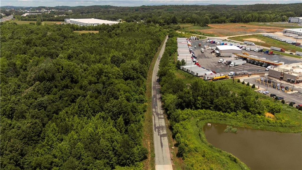
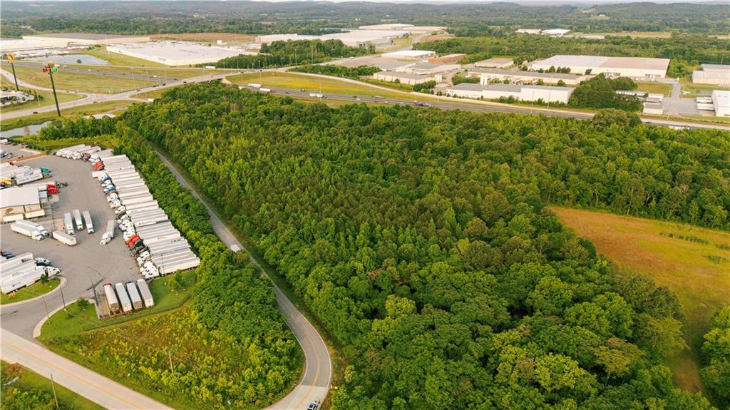
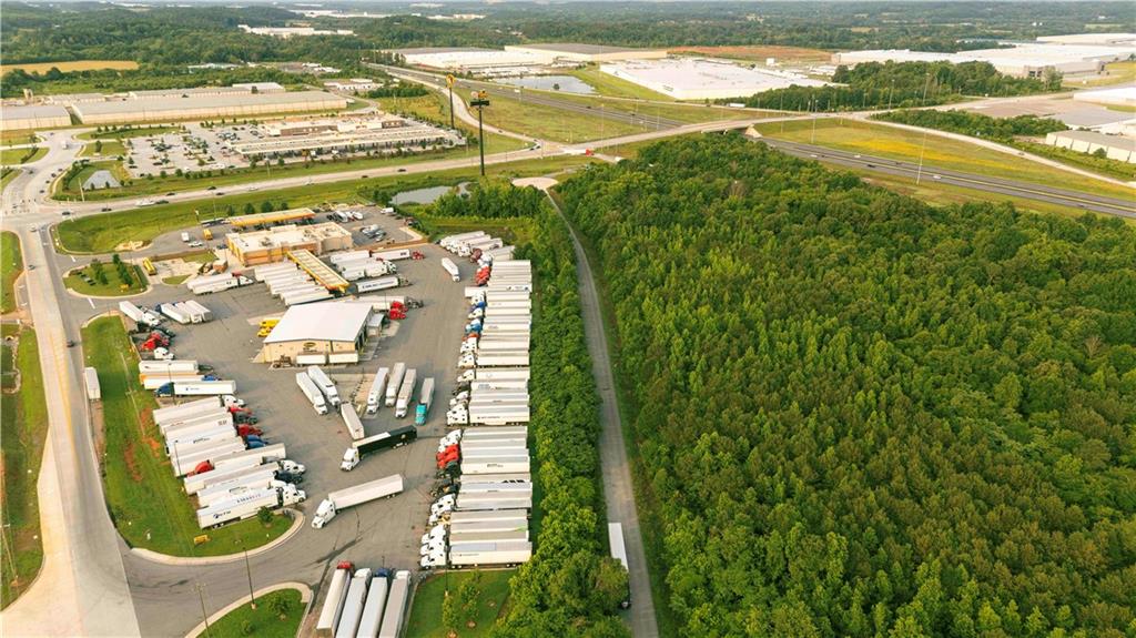
00 Belwood Road, Calhoun, GA 30701

Price

$3,000,000

Property Video

Property Details for 00 Belwood Road

Belwood Road

MLS#7588259

Save Property
Prime Commercial Development Opportunity – 20.49 Acres in a High-Visibility Location. Unlock the potential of this exceptional 20.49-acre parcel, strategically located in one of Calhoun’s busiest commercial corridors. Zoned C-2 with potential for Industrial zoning, this highly sought-after property sits directly across from Buc-ee’s at Exit 310 off I-75 and borders Love’s Truck Stop, offering unmatched exposure and constant traffic flow. With immediate access to major highways and positioned in a rapidly expanding market, this site is perfectly suited for retail, hospitality, industrial, or service-based developments. The property's size, zoning flexibility, and prominent location make it an ideal choice for developers and investors aiming to meet growing demand in this thriving area. Opportunities like this are rare—capitalize on the visibility, accessibility, and growth potential this premier site offers. Now is the time to invest in success.

Listing Agents

Exterior Details

Built In1900
StoriesOne
UtilitiesCable Available, Electricity Available, Sewer Available, Water Available
SewerPublic Sewer
Lot DescriptionLevel, Sloped
Lot Dimensionsx
Acres20.49

Location

Zip Code 30701
City Calhoun
County Gordon - GA

First Multiple Listing Service

Listing Provided Courtesy Of: Coldwell Banker Kinard Realty 706-629-8818

Listings identified with the FMLS IDX logo come from FMLS and are held by brokerage firms other than the owner of this website. The listing brokerage is identified in any listing details. Information is deemed reliable but is not guaranteed. If you believe any FMLS listing contains material that infringes your copyrighted work please click here to review our DMCA policy and learn how to submit a takedown request. © 2025 First Multiple Listing Service, Inc.

This property information delivered from various sources that may include, but not be limited to, county records and the multiple listing service. Although the information is believed to be reliable, it is not warranted and you should not rely upon it without independent verification. Property information is subject to errors, omissions, changes, including price, or withdrawal without notice.

For issues regarding this website, please contact Eyesore, Inc. at 678.692.8512.

Data Last updated on July 30, 2025 7:37pm

Get In Touch Connect With Us

    Accessibility Tools